In this section of the exercise you will analyses a hypothetical earthquake, to determine whether there is the potential for a tsunami. You may assume that a submarine earthquake of Richter magnitude M = 5 or great could generate a tsunami large enough to be of concern to coastal areas, even distant coastal areas. Your immediate concern is for the safety of the citizens of the U.S. Virgin Islands.
2.1 Record the current time on your answer sheet, as "Starting Time."
A large earthquake has just taken place in the Caribbean. The event is called to your attention at 13:30:00 GMT (hours:minutes:seconds, Greenwich Mean Time) by the folks over at the University of Puerto Rico, Mayaguez. The following seismograms are instantly available, electronically of course, from three seismic stations (1) Port of Spain, Trinidad, (2) Mayaguez, Puerto Rico, and (3) Kingston, Jamaica. Your objective is to determine the epicenter, and Richter magnitude. With this information you will be able to judge the source of the earthquake (e.g., reverse fault, normal fault, strike-slip fault, volcanic eruption), and whether the magnitude warrants evacuation of coastal areas of the U.S. Virgin Islands.
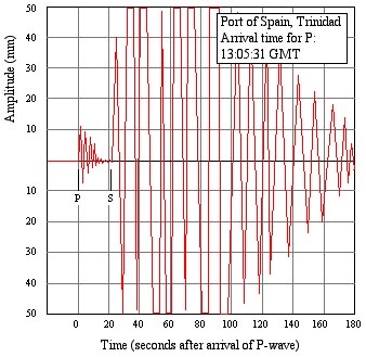
Seismogram #1
On your answer sheet record the following measurements:
Arrival time of the P-wave.
S-P interval (seconds).
Amplitude (mm). NOTE: In this seismogram the peaks are off-scale (square tops).
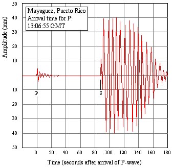
Arrival time of the P-wave.
S-P interval (seconds).
Amplitude (mm).
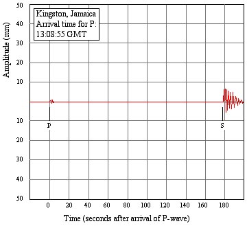
Arrival time of the P-wave.
S-P interval (seconds).
Amplitude (mm).
Now, for each seismic station determine the distance to the epicenter using the following graph. The S-P interval gives the distance to the epicenter. Record the distances on your answer sheet. Also, where possible, record the travel time of the P-wave.
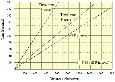
2.2 When did the earthquake occur? You can determine this by subtracting the travel time of the P-wave from the arrival time of the P-wave. Try it for seismograms 1 and 2.
T(0) = (P-wave arrival time) - (P-wave travel time)2.3 Do the times agree? They should.
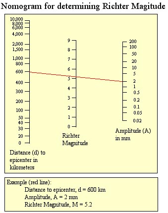
The next step is to determine the Richter magnitude. This can only be done for seismograms that did not go off-scale. Use the following nomogram to determine the magnitude.
2.4 Does the magnitude warrant concern for a tsunami?
To be on the safe side, perhaps you should locate the epicenter. Using a compass on your copy of the map shown below, around each seismic station (Port of Spain, Trinidad; Mayaguez, Puerto Rico; Kingston, Jamaica), draw a circle having a radius of the distance to the epicenter.

Show the location of the epicenter on your copy of the map.
2.5 If the earthquake causes a tsunami, how long will it take (in minutes) to reach the Virgin Islands?
2.6 At what time would the tsunami arrive at the Virgin Islands? NOTE: (arrival time of tsunami) = (time of earthquake t(0)) + (tsunami travel time)
2.7 What is the distance from the source of the tsunami to the Virgin Islands?
2.8 Given the distance (d) of the source from the Virgin Islands and the time (t) it takes for the tsunami to cover that distance, what's the average velocity (v) of the tsunami (in kilometers/minute)? (in kilometers/hour)? NOTE: v = d/t
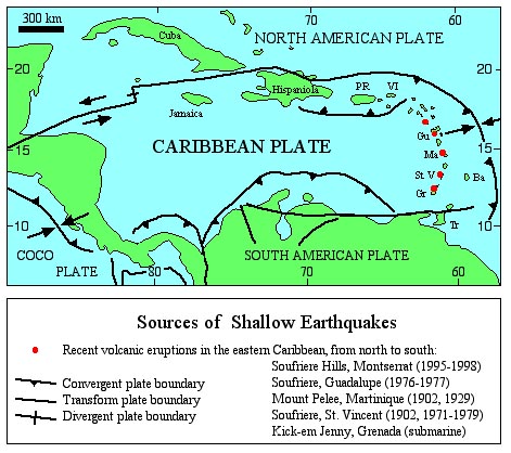
Now that you have located the epicenter, you can relate this to known plate tectonic boundaries or active volcanoes. Using the following map, postulate a likely source for the earthquake.
2.9 What is the source of the earthquake?
2.10 Is this a potential source for a tsunami?
2.11 Record the current time on your answer sheet, as "Finish Time."
2.12 How long has it taken you to do this part of the exercise? ("Finish Time" - "Starting Time")
2.13 Add this time to 13:30:00 GMT, the hypothetical time when you first received news of the earthquake.
2.14 Compare this hypothetical time with the hypothetical anticipated arrive time of the tsunami. Is there any time left to sound a warning and evacuate the coastal areas?
2.15 How much time do you have left?