3D Interactive Representations of Active Faults in Southern California
Based on the Southern California Earthquake Center Community Fault Model
Along with my collaborators, Michele Cooke (UMass), Gareth Funning (UC Riverside), and Susan Owen (Jet Propulsion Lab), and Andrew Meigs (Oregon State University) we have been creating 3D mechanical models of active faulting in southern California for the last decade or so. These models would not have been possible without access to the Southern California Earthquake Center (SCEC) Community Fault Model (CFM). While the CFM is a great resource for geophysicists and geologists alike, it is not optmized for numerical modeling. The mesh density reflects the source data density, so the mesh is highly irregular and many faults have small gaps and overlaps, preventing accurate mathematical simulation. Thus, to use the CFM in a numerical model, it must be remeshed, a process that easily can take even an expert several months or more to get a numerically-stable mesh. In the meshes below, we have put forth considerable effort to honor the CFM's complex geometries while creating an approximately mesh with no gaps, holes, or overlaps. Also, the CFM only extends faults to the base of seismicity (~15 km). To model interseismic deformation, we need to have representations of the sub-seismogenic portions of faults (>15 km depth), so we have extended major faults to 27.5 km depth. If you have any questions or are intersted in using our meshes, please contact me (marshallst<at>appstate<dot>edu).
Instructions for Viewing 3D Models
These 3D PDF files require Adobe Acrobat Reader or Professional 7.0 or later for 3D capabilities. Please note that Apple's Preview, Foxit Reader, or pdf viewers built into Mozilla Firefox or Google Chrome cannot render 3D data. You must use Acrobat! A three-button or scrolling mouse is also highly recommended.
- To view the three-dimensional modeled fault mesh, click one of the three models below. To avoid your browser from opening the files in a built in viewer (which cannot render 3D data), you may want to right-click on the image and select "save link as..." and save the pdf file to your computer.
- To activate 3D rendering, click the left mouse button in the indicated gray area. Warning: The instruction screen will disappear upon activating 3D rendering. To return to the instruction screen, right click on the 3D model and select “disable content.”
- Upon activating 3D, the pdf file will load the 3D model in map view. For instructions on how to navigate in 3D, read the opening page of the pdf file, or read the instructions below.
- To see fault name labels use the view manager pull-down menu near the top left of the screen. Select the view called “map view (fault names)." Labels will disappear upon clicking the mouse.
- The default view, ”map view,” can be returned to at any time by clicking on the little house icon near the top left corner of you Acrobat window.
3D Driving Instructions
Navigating in 3D takes some practice, but with time you will get comfortable with the controls, so don't give up! Instructions are below:
- Rotate: Hold down on left mouse button and move mouse in the direction of rotation.
- Zoom in/out: Hold on the right mouse button and move the mouse up and down.
- Translate/Move: Hold down on the right and left mouse buttons at the same time and move mouse in the direction you wish to move.
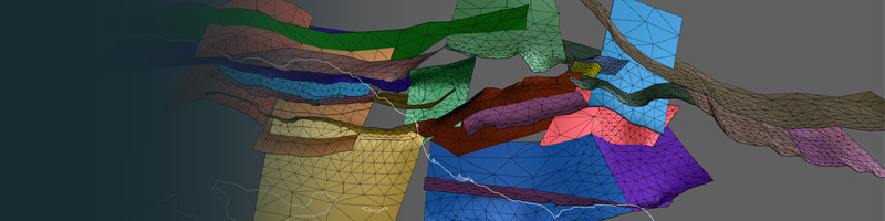
3D Fault Model of the Western Transverse Ranges, CA
Above: Three-Dimensional Interactive Fault Mesh of The western Transverse Ranges Region, CA based on the Southern California Earthquake Center Community Fault Model, version 4.0. This mesh was used in Marshall et al. (2013).
Downloads: Modeler-Ready Ventura Fault Meshes
Each mesh is provided as a zipped tarball (.tgz) file, which includes the mesh (in gocad t-surf format), a README.txt file with instructions, two perl scripts for converting from gocad to matlab or facet formats, and a MATLAB function, plotMesh.m, which can be used to make basic visualizations of the meshes/faults in 3D. All meshes are in UTM coordinates (zone 11, meters) using the NAD27 datum. If you have any questions about these meshes, feel free to contact me for more information.
Ventura mesh based on the CFM version 4.0 (Marshall et al., 2013) --> Download Mesh
Ventura Special Fault Study Area mesh #1 (Kamerling et al., 2003, No Ramp) --> Download Mesh
Ventura Special Fault Study Area mesh #2 (Hubbard et al., 2014, Ramp) --> Download Mesh
3D Fault Model of the Greater Los Angeles Region, CA

Above: Three-Dimensional Interactive Fault Mesh of The western Transverse Ranges Region, CA based on the Southern California Earthquake Center Community Fault Model, version 2.5. This fault mesh was used in Marshall et al. (2009), and an early version of this mesh was used in Cooke & Marshall (2006), Meigs et al. (2008),
3D Fault Model of the Greater Ventura Basin Region, CA

Above: Three-Dimensional Interactive Fault Mesh of The Ventura Basin Region, CA based on the Southern California Earthquake Center Community Fault Model, version 2.0. This fault mesh was used in Marshall et al. (2008).