
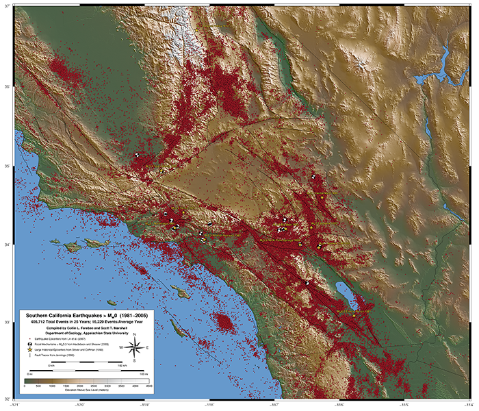
Map of Southern California Earthquakes from 1981-2005
Collin Ferebee || Spring 2009
Collin Ferebee, an undergraduate student in the department of geology, worked with me during the Spring of 2009 to produce poster-sized maps of relocated seismicity in California. Collin gathered the relocated hypocentral data from published papers and wrote a Generic Mapping Tools script to plot this beautiful earthquake map. PDF files are below for download, although we caution that these files are very large and may require > 1Gb of free RAM to visualize in Adobe Acrobat, so be patient! We recommend right clicking on the PDF files below and selecting "save link as" to prevent your browser from timing out.
Map Details and Source Data
Digital elevation data used on the maps was converted from the USGS Seamless Data Server and comes from the National Elevation Dataset. The earthquake locations come from Lin et al. (2007) relocated hypocentral data, and focal mechanisms (i.e. beach balls) are from Hardebeck & Shearer (2003). The GMT script requires a Bash shell and a number of files to function properly, but we provide the script so that students and other researchers browsing this site can see what the code looks like that created these maps. The maps just scratch the surface of what Generic Mapping Tools is capable of. The pdf file is in vector graphics format, so it is the highest quality; however, the pdf is 95 Mb, so be patient when downloading and opening it! I recommend right clicking on the file and selecting "Save Link As..." to save the file to your computer. This should prevent your browser from timing-out during the download. Alternatively, we have also provided a smaller rasterized PNG image. See below for download links.
Southern California Seismicity and Focal Mechanisms from 1981-2005
Download the Earthquake Map :: PDF (49" x 42", 95 Mb) :: PNG (3000x2571 px, 14.1 Mb) :: GMT script