Seismic Sea Waves
Seismic Sea Waves
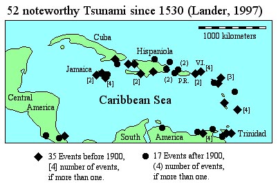
The following account is from a report by Lander (1997) on tsunami in the Caribbean:
"1867, Nov. 18, St. Thomas, Virgin Is.
At Charlotte Amalie the height [of the seismic sea wave] was 2.4 m at the wharf, and the lower part of the city was flooded. The water receded nearly 100 m and returned as a wave 4.5 to 6 m high swamping small boats in the harbor. The wave penetrated 76 m inland. The USS De Soto was damaged, 11-12 people were killed. At Altona, houses were washed far inland, and there was damage at Hassel I. At Christensted, St. Croix, waves swept inland 91 m, and at Gallows Bay, 20 houses were damaged. At Fredricksted the sea withdrew and returned as a wall of water 7.6 m high leaving the USS Monongahela stranded. Five were killed, 3-4 injured, and 20 houses were damaged. At Puerto Rico, at San Juan, the river water rose 0.9-1.5 m and at Vieques, high waves were observed. At Fajardo, a very small wave was reported, and at Yabucoa the sea retreated and inundated 137 m on its return. In the British Virgin Islands, at St. Peter I., a wave was noted and people fled to Tortola. At Roadtown, Tortola, a 1.5 m wave swept some houses away. At Saba, there was some damage. At St. Christopher the wave was also observed. At St. Martin and St. Bartholemy there was some damage. At St. Johns, Antigua, the wave had a height of 3.0 m. At Basse-Terre, Guadeloupe, the height was 1.0 m with the sea retreated far from coast. At Deshailes, houses in village were destroyed. At Isle des Saintes there was a slight swell, and at Fond du Cure, houses inundated to a depth of 1 m. At Pointe-a-Pitre there was a slight swell, and at Sainte-Rose, a 10 m wave. The sea withdrew 100 m and flooded and damaged houses on return. It was observed at Martinique and St. Vincent had unusually high water. At Grenada, Gouyave (Charlotte Town) the height was 3 m and at St. George, 1.5 m. At Becquia Island it was 1.8 m. ..."Most seismic sea waves, also known as tsunami*, are barely perceptible in the open sea, and only detectable near shore from tidal gauge records. The occasional large events are well known in the circum-Pacific region. Not so well know are the occasional large events affecting the Caribbean (see diagram above). Contrary to popular belief, tsunami usually do not present a monstrous wall of water crashing onto the shore. Although this can happen, depending on the shape of the coast line, distribution of islands and shoals, and geometry of the sea floor near the coast. Without dispelling the myth completely, the fact is, most tsunami involve a more or less gentle, but dramatic, rise (run-up) or fall (draw-down) of sea level over the course of minutes. The run-up can involve extensive flooding of low-lying areas, and rafting of floating object far inland. Subsequent draining back into the sea can cause as much damage as the run-up. Sometimes an event starts with draw-down, draining the water from harbors, bays, and other shallow areas. The momentum of the returning sea can wash onto the land, rafting floating objects with it. While the effects can be likened to a storm surge associated with a hurricane, quite unlike a hurricane storm surge which takes place over the course of several hours, a tsunamic event takes place over the course of 10 or 20 minutes. Because of the shorter duration but comparable changes in sea level, currents associated with run-up or draw-down are greatly accelerated for a tsunami.
The exercise is organized into two parts. In the first part you will learn about the causes of tsunami and the characteristics of the resulting tsunamic (seismic sea) waves. In the second part of the exercise, you will learn something about tsunami prediction in the context of a hypothetical situation in the Caribbean.
For additional information an excellent starting point is the web-site, Tsunami!: The WWW Tsunami Information Resource, managed by the Department of Geophysics, University of Washington, Seattle, WA.
* The term tsunami is both singular and plural. However the AGI Glossary of Geology acknowledges, in deference to popular use, that tsunamis (pl.) is also acceptable.
PART 2. Tsunami Prediction. For printing a copy of the ANSWER SHEET. NOTE: You will need a compass (for drawing circles).
Lander, J.F., 1997, Caribbean tsunamis: an initial history. in Ahmad, R. (ed.), Natural Hazards and Hazard Management in the Greater Caribbean, Publication No. 3, Unit for Disaster Studies, University of the West Indies, Mona, Kingston, Jamaica, pp. 1-18.
(2005)