IN THE LESSER ANTILLES OF THE EASTERN CARIBBEAN
(photo courtesy of Gary Sego)
IN THE LESSER ANTILLES OF THE EASTERN CARIBBEAN
(photo courtesy of Gary Sego)
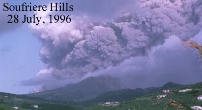
In 1995 the Soufriere Hills volcanic complex (a stratovolcano) in the small island nation of Montserrat entered an eruptive phase which continued sporadically until 1998. The prolonged main stage of eruption began in July, 1996, when this photograph was taken. Check out more photographs at the site, called Montserrat Volcano Observatory - Pictures, prepared by the observatory, especially the photographs for 26-28 July, 1996, one of which is shown above.
Leading up to the catastrophic explosion, the volcano displayed plenty of warning signs in the form of increased production of steam and ash, seismic activity, and a subtle steepening of the flanks of the volcano. The latter phenomenon, a common precursor to a major eruption, is caused by the movement of the magma upward through the crust, pushing up the overlying landscape and effectively inflating the volcano.
About half of the island's 10,000 residents were evacuated to the northern third of the island, neighboring islands, and more distant places, like England, the United States and Canada. Fortunately, the evacuation took place well before the main eruption. Unfortunately, the devastation caused by the eruption completely destroyed the capitol city of Plymouth and rendered the whole southern two-thirds of the island essentially uninhabitable even today.
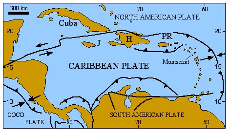
Montserrat, a tiny volcanic island barely 100 km2 in area, is part of a chain of volcanic islands making up the Lesser Antilles in the eastern part of the Caribbean basin. The islands form an arc just west of the convergent part of the plate boundary separating the Caribbean plate and the North American plate.
In this part of the exercise you will compare the Soufriere Hills with Mount St. Helens. First, let's take a closer look at the island, and it's tectonic setting. Below, you can examine a larger-scale map of the tectonic setting, and a cross-section. The scale is the same as the scale used for the maps and cross-sections of Mount St. Helens and the Island of Hawaii.
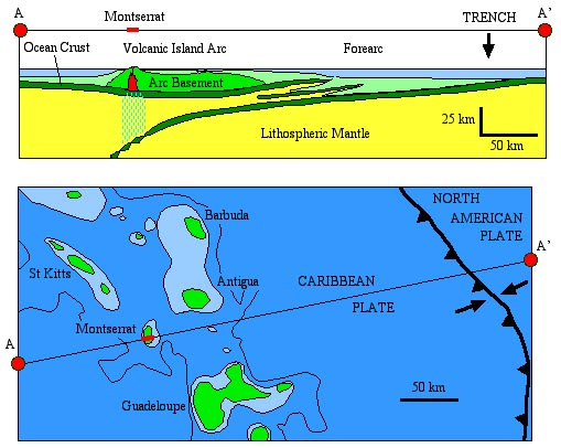
Earthquakes in the vicinity of Montserrat originate at depths of about 70 km, near the top of the westward-subducting North American plate. The volcanic material making up Montserrat is mainly andesite.
3.1 Briefly describe how the andesitic magma is formed.
3.2 What causes catastrophically explosive eruptions of andesitic magma?
Compare and contrast the tectonic setting with the tectonic setting of Mount St. Helens.
3.3 What are the similarities?
3.4 What are the differences?
Now let's look at the volcano itself, for comparison with Mount St. Helens.
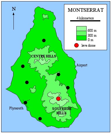
Montserrat actually consists of three main volcanic centers, (1) a northern center, which appears as the bit of high ground near the northern tip of the island, (2) the Central Hills, and (3) the Soufriere Hills. Only the Soufriere Hills are currently active. The flanks of the Soufriere Hills consist of various pyroclastic materials and remobilized pyroclastic material (landslides, lahars). The lava dome produced in the most recent eruption, and surrounding older lava domes, consist of obsidian and pumice. The elevation at the top of the most recent lava dome (red circle) is 967 m. The base of the volcano is just off-shore. You may take 6 km as a reasonable radius for the volcano.
3.5 Estimate the volume of volcanic material in the Soufriere Hills, in cubic milometers (km3). Model the structure as a simple cone. The volume of a cone is given by the following formula,
volume = (1/3)*pi*r2*h,where pi ~ 3.14, r = radius of the cone, and h = height of the cone.
3.6 How does the volume compare with the volume of Mount St. Helens?
Here is a topographic map of central vent area of the Soufriere Hills.
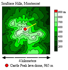
Note that the vent area is more complicated than the vent area of Mount St. Helens. The Soufriere Hills, as the name implies, consists of a number of peaks. Each of these peaks is a lava dome. The most recent lava dome (red) was emplaced between 1995 and 1998. Most of the slopes are deeply gullied by erosion of older pyroclastic deposits. The surface just northeast of the new lava dome is relatively fresh. You may assume that the slope here (along the yellow line) is controlled by the angle of repose of the pyroclastic material. Elsewhere, especially in the gullied areas, the partially lithified materials have been steepened by erosion and slope failure.
3.7 Along the 1 km-long yellow segment, what is the slope and angle of the slope?
3.8 How does this compare with the slope of the sides of Mount St. Helens?
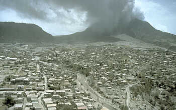
Plymouth, capitol of Montserrat, 12 July, 1997, covered in ash.
(photo by R.P Hoblitt, courtesy of USGS, more
images)
CONGRATULATIONS, YOU HAVE COMPLETED THE THIRD AND LAST PART OF THE LAB EXERCISE.