Movement on Normal Faults is accompanied by vertical movement where two lithosphere plates are being pulled apart (tension). The movement is normally (pardon the pun) downward. This is the characteristic type of fault at a divergent plate boundary. Divergent plate boundaries are marked by oceanic ridges.Movement on Reverse Faults are accompanied by vertical movement where two lithospheric plates are being pushed together (compression). The movement is usually upward. This is the characteristic type of fault at a convergent plate boundary. You will recall that at a convergent plate boundary one lithospheric plate is being shoved beneath the edge of another plate. The process is called subduction. Convergent plate boundaries involving oceanic lithosphere are marked by deep, oceanic trenches, which very nearly mark the actual position of the plate boundary on the sea floor. The area near the trench is subject to sudden vertical movements.
Movement of Strike-Slip Faults involves no vertical movement, thus does not directly represent a source for tsunami. The movement is horizontal. This is the characteristic type of fault at a transform plate boundary.
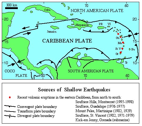
VOLCANIC ERUPTIONS. In ocean basins there are three
situations
of concern:
A Volcanic Island Arc is formed above the subduction zone adjacent to a convergent plate boundary, hence is parallel to the oceanic trench but offset from the trench by 300 km or more. The magma is typically andesitic to rhyolitic. Volcanic eruptions can be catastrophically explosive, and can cause a sudden rise or fall of the landscape.Hot Spot volcanism in the oceanic basins involves basaltic magma. The locations of hot spots, which are formed above mantle plumes, are quite independent of plate boundaries. An example is the island of Hawaii. The newest eruptive center near Hawaii is the submarine volcano of Loihi, just off the south coast of Hawaii. Hot spot eruptions are not normally accompanied by large, sudden, vertical movements of the sea floor. There are no such hots spots in the Caribbean basin.
Basaltic volcanism occurs along divergent plate boundaries, where new oceanic crust is formed at oceanic ridges. The eruptions are not known to produce large, sudden, vertical movements of the sea floor.
SUBMARINE LAND SLIDES:
Submarine landslides can involve sediment and rock dislodged from any relatively steep, submarine slopes. Such slopes may occur on the submarine flanks of a volcano, or on the rise from sea floor to the shelf of any land mass, continental or otherwise. Vertical displacement of the surface of the sea can be complicated. Above the site of dislodgment, the sea surface is effectively sucked down, but where the dislodged material slides on the deeper sea floor, the overlying water is displaced upward.
METEOR IMPACTS:
Let's hope not, but catastrophic meteor impacts in the past are now well documented. One of the largest, and best documented, happened 65 million years ago and marked the close of the Cretaceous Era. The site of the impact was the Yucatan Peninsula in Mexico. Evidence for a seismic sea wave has been identified throughout the Caribbean basin.Examine the map below and note the potential sources of tsunami in the Caribbean basin:
WAVE MECHANICS
WAVELENGTH: The distance between the leading edge of the wave and the trailing edge of the wave (wavelength) can exceed 200 kilometers in the case of a tsunami. So, the seismic sea wave propagates across the open sea with a very long wavelength and very low amplitude. The aspect ratio, amplitude/wavelength, is very small, about 1/200,000. The passage of such a seismic sea wave beneath a ship at sea would go unnoticed.
VELOCITY: The velocity of a seismic sea wave, in the open sea, can be faster than 700 km/hr! The velocity depends on the depth to the sea floor, according to a simple formula,
V = (d x g)1/2where V is the velocity (in m/s), d is the depth to the sea floor (in m), and g is acceleration due to gravity (10 m/s2). Through this equation it is apparent that a tsunami wave slows down as it approaches a coastline.
TRAVEL TIME: Of course the travel time for a tsunami is going to depend on the velocity of the tsunami, or more specifically the depth of the water. The diagram below gives the travel time (in minutes) to the Virgin Islands for a tsunami originating anywhere in the Caribbean basin. For instance, if a tsunami starts just off the north coast of Curacao, it would take approximately 90 minutes to reach the Virgin Islands. For other locations around the world visit NOAA National Geophysical Data Center, where you can prepare your own travel time maps.
SHOALING: Regardless of the water depth, the total volume of water in the wave tends to remain constant (well, at least in an ideal world). As a wave approaches a coastline the leading edge of the wave slows down before the trailing edge. Thus there is a tendency for the trailing edge to "catch up" to leading edge. The wavelength becomes shorter. Since the volume of water remains the same (ideally), it has nowhere to go but up. The amplitude increases, typically not more than 5 to 10 m above normal sea level, and only very rarely up to 40 m above normal sea level. For most tsunami, the run-up is slow enough (~ 1 m/minute) that the wave does not break onto the shore. Rather, from the perspective of an observer, the sea level simply rises (in the case of run-up) or falls (in the case of draw-down) dramatically over the course of several minutes. Rarely does run-up reach a point where the front of the wave becomes oversteepened and unstable, causing the wave to "break." That's the scenario for a monstrous, wall of water crashing onto a shoreline. Most tsunami do not behave this way, except where the amplitude is enhanced locally by the shape of the shoreline and topography of the near-shore sea floor.

QUESTIONS (refer to the information above):
1.1 What are the potential sources of tsunami within a 1000 km radius of the Virgin Islands?
1.2 The greatest depth to the sea floor in the Caribbean basin is just south of Hispaniola in the Muertos Trench. The depth is just over 5000 m. What is the velocity for a tsunami where the water depth is 5000 m?
1.3 A tsunami originates just off the south coast of Jamaica, near Kingston (yellow dot on map above). How long will it take for the tsunami to reach the Virgin Islands?
1.4 Notice that away from the coastal areas the spacing between lines of constant travel time is more or less constant. What does this mean with regard to the depth of the water over most of the basin?
1.5 Within the Caribbean basin, measure the distance between the 50-minute contour line at the "50" and the 150-minute contour line at the "150." This is the distance covered by the tsunami in 100 minutes (150-50). What is the average velocity for a tsunami crossing the Caribbean (in Km/minute)? (in kilometers/hour)? NOTE: V = d/t
1.6 Actually, you can rearrange the tsunami velocity formula to calculate the average depth to the sea floor, d = V2/g. Using this rearranged form of the velocity equation, and the velocity obtained in Question 1.5, calculate the average depth to the sea floor. (The observed average depth to the sea floor in this region is about 4000 m).
1.7 You are on a boat at sea and a tsunami passes beneath you. The wavelength is 200 km. Using the velocity you just calculated for Question 1.5, how long would it take for the wave to pass beneath the boat (in minutes)?
1.8 Suppose now that the height of the tsunami that just passed beneath your boat was just 100 cm. How long would it take for the boat to be lifted 100 cm (in minutes)?
1.9 O.K. now you are in a position to calculate the rate of uplift of the sea surface, which would be? NOTE: average velocity of uplift, v = d/t
O.K., we're done here.