
Recent and Ongoing Research Projects
Fault Mechanics | Geodesy | Community Models | Data Science | Near-Surface Geophysics
As a geophysicist and earthquake scientist, I focus primarily on understanding how active faults accumulate and release stress over time. However, I have also branched out into several other intriguing research areas as opportunities have arisen. My research projects typically fall into one of the following categories:
- Computational Models of Active Faulting
- Satellite Geodesy
- Community Model Development
- Data Science
- Near-Surface Geophysics
Computational Models of Active Faulting
Many people mistakenly think that the San Andreas fault is the main or only significant earthquake source in California. The reality is that the San Andreas is just one of hundreds of active faults. Many of these other faults are less well studied. Computational models offer a way to better understand these faults, especially for faults which may not be possible to directly study with geologic field analyses. My past and ongoing efforts are aimed at using physics-based models to predict both long-term and current day fault slip rates across the complex network of faults in California.

Figure 1: Fault trace map from Devine et al. (2022). We estimated fault slip rates for 80 faults throughout the Transverse and Peninsular Ranges of California. This is our largest simulation to date and many of these faults had no previous slip rate estimates. Red faults were identified as potentially inactive while the blue faults had slip applied based on existing slip rate estimates.

Figure 2: While Figure 1 shows a 2D map of fault traces, the models we produce are 3D. Above is a screen shot of the CAD (Computer Aided Drafting) software that we use to build the models. Note that each fault above is given a different color, only to delineate where each fault begins and ends. Because faults have complex 3D shapes, we split fault surfaces into many triangular elements and slip rate is solved for on each element. Some of our previously published meshes are described in more detail with links to download and view/interact with the meshes on my 3D fault models page.
Satellite Geodesy
Global Navigation Satellite System (GNSS) and Interferometric Synthetic Aperture Radar (InSAR) data can be used to measure motions of the surface of the Earth at the sub millimeter scale. With these advanced techniques, we can now quantify spatial and temporal variations in strain, seasonal deformation, and anthropogenic deformation. Once all non-tectonic motions have been characterized, we can mathematically remove them and the complex tectonic deformation patterns emerge.

Figure 3: The map above shows Line of Sight (LOS) motions calculated from InSAR data collected by the Envisat satellite with the deformation due to the San Andreas fault mathematically removed. The LOS is close (but not exactly) vertical, so positive values generally indicate uplift and negative subsidence. In this image, Marshall et al. (2013) identified siz areas of non-tectonic motions (shown with black rounded rectangles). A and C show subsidence due to active hydrocarbon exctraction, B, D, and E indicate subsidence due to groundwater extraction for agricultural uses, and the cause of subsidence at E is unknown, although we hypothesized that it could be related to groundwater extraction by a large nursery. White arrows show GNSS velocities relative to station CIRX, which overall indicate approximate N/S shortening.
Community Models and Data Science
The Statewide California Earthquake Center (SCEC) supports a suite of Community Earth Models (CEMs). Since 2017, I have been the co-leader of the Community Models group and I have taken on many data science roles that involve automating, standardizing, and visualizing, CEM data. I have also been involved in the development of many of the SCEC CEM Explorers, web-based tools that allow users to quickly interact with, query, visualize, and download portions of the CEMs. I have served on the development teams for the Community Fault Model (CFM), the Community Stress Model (CSM), the Community Velocity Model (CVM), and I am the co-creator of the SCEC Geologic Slip Rate Database.

Figure 4: Screenshot of the SCEC CFM Explorer web interface that I co-developed with colleagues at Harvard University and the Statewide California Earthquake Center. While many improvements and changes have been made, this was the first SCEC Community Model web-interface and formed the backend code of all of the subsequent CEM Explorers. The CEM Explorers are javascript implementations of Leaflet, an open-souce library for map-based visualizations.
Data Science
Through my computational fault modeling research, I have developed a passion for data science. Data science is a broad field, but at a basic level, it involves using computer programming and mathematics to gain knowledge from data. This is actually what scientists do and given my experience with automating fault models and their visualizations, I have found that I enjoy writing code, especially if it takes messy data and turns it into a useful and understandable visualization. I have been fortunate to collaborate in numerous projects where my role was automating cleaning, acquiring, or visualizing data. If you have data that you need visualized or automated in some way, I'm happy to discuss. Oh, and did I mention that I also enjoy building my research desktop computers? I'm a geek.

Figure 5: Visualization of African footprints preserved in volcanic ash in Tanzania. This was a project that GES colleagues Brian Zimmer and Cynthia Liutkus had been working on for several years before I joined. Their group had taken numerous photographs from different angles and performed "structure from motion" calculations to derive 3D models of the footprints. This process was repeated several years later (compare the left and right columns in the figure for the two different times). My task was to write some software that would process the 3D data and make calculations and visualizations of how the footprints had changed over time (due to weathering/erosion and deposition). The software reads the footprint data, performs some necessary data cleaning, plots the data, and allows the user to click on starting and ending points to produce a profile across the footprints to highlight any changes. With this and other tools, we were able to quantify the degradation patterns of the footprints over time. This work was published in 2018 in Quaternary Science Reviews.
Near Surface Geophysics
In my GES3160 course (Introduction to Geophysics), I teach about several near-surface geophysical methods. Many years ago, I was fortunate to secure funding to purchase equipment to perform Ground-Penetrating Radar (GPR), direct current electrical resistivity, and refraction seismology surveys. Since then, my students and I have collected a ton of data that can be used to non-invasively image the subsurface. This has led to many great student projects, a publication on locating archaeological sites, and a publication involving permafrost and ice wedges in Alaska. I love the excitement of being able to find (and subsequently explain) mysteries underground with geophysics and I look forward to continuing these projects as opportunities arise.

Figure 6: Oblique 3D view of a fence diagram from Taylor Arrowood's senior thesis showing the electrical resistity profiles collected at ASU Greenway over an approximately ten year period. These profiles took years of geophysics students efforts to gather. Now more than a decade later, we have near-surface geophysical data covering nearly the entire north portion of the floodplain of the south fork of the New River.
Below are research topics that I have published papers about, but no longer work on. These are super interesting topics, so perhaps someday I will return to them.
Miocene Faulting in the Lake Mead Fault System, Southeast Nevada
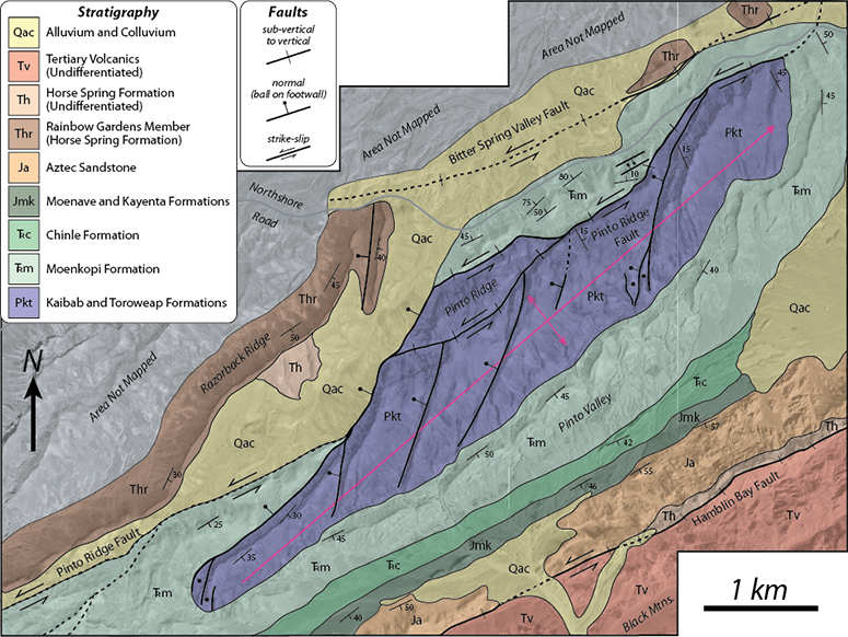
Even the shallowest earthquakes nucleate at depths > 1 km, so we typically can't directly observe earthquake-related processes and the complex fault structures responsible for these events. What we can do is observe exhumed ancient fault systems that were once active and try to understand their structure and behavior. Once such fault system that I have worked on is the Lake Mead fault system, located just east of Las Vegas, Nevada. Here, both field mapping and mechanical modeling evidence suggests that strike-slip and normal faults are genetically related, and a regional-scale west-dipping detachment is likely present at depth.
Fracturing and Faulting on Jupiter's Icy Moon, Europa
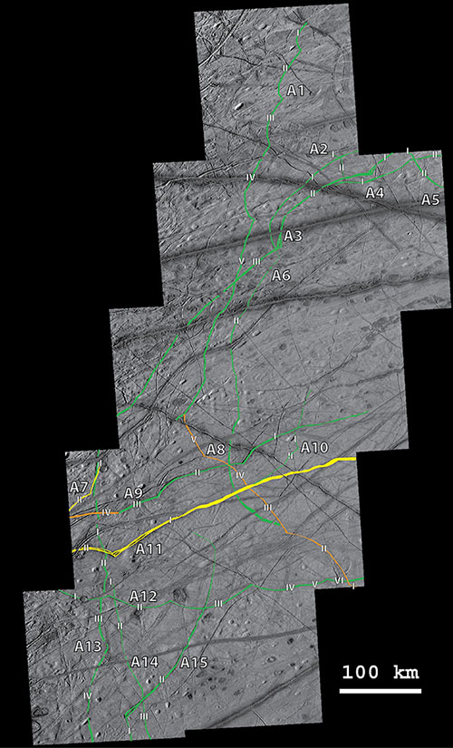
Diurnal tidal forces (from Jupiter) have resulted in a highly fractured surface on Jupiter's moon, Europa. Fractures follow the same physical laws whether on Earth or other planetary bodies, so we can use the principles of fracture mechanics to understand fractures on other planetary bodies. Curved cracks, called cycloids, or flexi, are unique to the surface of Europa and may form due to a combination of opening, shearing, and secondary fracturing due to diurnal tidal forces. We have also documented several examples of previously unrecognized strike-slip faulting and secondary fracturing on Europa's heavily fractured icy surface.